Description

This program will give you access to the most advanced knowledge in Geomatics and Geoinformation so that you can incorporate the best tools available into your work”
##IMAGE##

New technological and digital tools have allowed disciplines such as Geomatics to improve their precision and efficacy. The emergence of these disruptive technologies has also led to the emergence of new professional profiles in this area such as the expert surveyor, the GIS specialist or the expert in 3D modeling focused on this sector. For this reason, professionals dedicated to this field must be aware of new innovations in order to be able to incorporate them into their work.

This Professional master’s degree in Geomatics Engineering and Geoinformation provides in-depth knowledge of these innovations, focusing on areas such as photogrammetry, geopositioning, applied information in this field; especially programming and the design and management of databases, using drones to represent terrain through photographic images, and many more. In this way, professionals will integrate the most innovative techniques into their daily work, allowing them to adapt to transformations in the sector and gain access to the new job positions that have recently emerged.

And all this will be achieved through an online teaching methodology, specially designed so that the professional can combine their work with their studies, without any kind of interruption. In addition, they will be guided throughout the entire process by a first-class teaching staff with extensive experience in this field, while the student enjoys numerous multimedia contents such as interactive summaries, practical exercises or master classes.

Gain in-depth knowledge of aspects such as photogrammetry while you enjoy a teaching methodology that is adapted to you, allowing you to decide when and where to study”

This Professional master’s degree in Geomatics Engineering and Geoinformation contains the most complete and up-to-date program on the market. Its most notable features are:

  • Practical cases presented by experts in Topographpy, Civil Engineering and Geomatics
  • The graphic, schematic, and practical contents with which they are created, provide scientific and practical information on the disciplines that are essential for professional practice
  • Practical exercises where the self-assessment process can be carried out to improve learning
  • Special emphasis on innovative methodologies
  • Theoretical lessons, questions to the expert, debate forums on controversial topics, and individual reflection assignments
  • Content that is accessible from any fixed or portable device with an Internet connection

In recent years, many new professional profiles have emerged in the field of Geomatics, such as the expert surveyor. This program gives you all the keys to successfully deal with this transformation”

The teaching staff of this program includes professionals from the sector, who contribute the experience of their work to this program, in addition to recognized specialists from reference societies and prestigious universities.

Thanks to multimedia content developed with the latest educational technology, you will be immersed in situated and contextual learning. In other words, a simulated environment that will provide immersive learning, programmed to train for real situations.

This program is designed around Problem-Based Learning, whereby the professional must try to solve the different professional practice situations that arise throughout the program. For this purpose, the student will be assisted by an innovative interactive video system created by renowned and experienced experts.

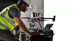
Thanks to this program, you will learn how to use drones map and represent the terrain by means of photographic images"
##IMAGE##

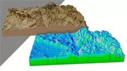
Know the latest computer tools applied to Geomatics with this Professional master’s degree"

Syllabus

This Professional master’s degree in Geomatics Engineering and Geoinformation at TECH has been developed to raise the qualification of engineering professionals to the highest quality standards. To this end, an exhaustive review of relevant subjects such as embedded systems, microelectronics, power converters, biomedical electronics and energy efficiency, among others, is proposed. Issues of great importance to achieve the level of competitiveness in students demanded by today's companies.

##IMAGE##

The syllabus of this Professional master’s degree includes relevant information on different areas of electronic systems”

Module 1. Expert Topography

1.1. Classic Topography

1.1.1. Total Station

1.1.1.1. Stationing
1.1.1.2. Automatic Monitoring Total Station
1.1.1.3. Measurement without a Prism

1.1.2. Coordinate Transformation
1.1.3. Topographic Methods

1.1.3.1. Free Stationing
1.1.3.2. Measuring Distance
1.1.3.3. Stakeout
1.1.3.4. Area Calculation
1.1.3.5. Remote Height

1.2. Cartography

1.2.1. Cartographic Projections
1.2.2. UTM Projection
1.2.3. System of UTM Coordinates

1.3. Geodesy

1.3.1. Geoid and Ellipsoid
1.3.2. The Datum
1.3.3. System of Coordinates
1.3.4. Types of Elevations

1.3.4.1. Height of the Geoid
1.3.4.2. Ellipsoid
1.3.4.3. Orthometric

1.3.5. Geodetic Reference Systems
1.3.6. Leveling Networks

1.4. Geopositioning

1.4.1. Satellite Positioning
1.4.2. Errors
1.4.3. GPS
1.4.4. GLONAS
1.4.5. Galileo
1.4.6. Positioning Methods

1.4.6.1. Static
1.4.6.2. Static-Rapid
1.4.6.3. RTK
1.4.6.4. Real Time

1.5. Photogrammetry and LIDAR Techniques

1.5.1. Photogrammetry
1.5.2. Digital Elevation Model
1.5.3. LIDAR

1.6. Property-Oriented Topography

1.6.1. Measuring Systems
1.6.2. Boundaries

1.6.2.1. Types
1.6.2.2. Administrative Boundaries

1.6.3. Easements
1.6.4. Segregation, Division, Grouping and Aggregation

1.7. Property Registration

1.7.1. Cadaster
1.7.2. Property Registration

1.7.2.1. Organisation
1.7.2.2. Registration Discrepancies

1.7.3. Notary

1.8. Expert Test

1.8.1. Expert Evidence
1.8.2. Requirements for Being an Expert
1.8.3. Types
1.8.4. Expert Role
1.8.5. Property Delimitation Tests

1.9. Expert Report

1.9.1. Steps Before the Report
1.9.2. People Involved in the Expert Procedure

1.9.2.1. Judge-Magistrate
1.9.2.2. Judicial Secretary
1.9.2.3. Procurators
1.9.2.4. Lawyers
1.9.2.5. Plaintiff and Defendant

1.9.3. Parts of the Expert Report

Module 2. Geopositioning

2.1. Geopositioning

2.1.1. Geopositioning
2.1.2. Objectives of the Positioning
2.1.3. Earth Movements

2.1.3.1. Translation and Rotation
2.1.3.2. Precession and Nutation
2.1.3.3. Pole Movements

2.2. Georeferencing Systems

2.2.1. Reference Systems

2.2.1.1. International Terrestrial Reference Systems. ITRS
2.2.1.2. Local Reference Systems. ETRS 89 (European Datum)

2.2.2. Reference Framework

2.2.2.1. International Territorial Reference Framework. ITRF
2.2.2.2. International GNSS Reference Framework. Materialization of ITRS

2.2.3. International Ellipsoids of Revolution GRS-80 and WGS-84

2.3. Positioning Mechanisms or Systems

3.3.1. GNSS Positioning
3.3.2. Mobile Positioning
3.3.3. WLAN Positioning
3.3.4. Wi-Fi Positioning
3.3.5. Celestial Positioning
3.3.6. Submarine Positioning

3.4. GNSS Technologies

2.4.1. Types of Satellite According to Orbit

2.4.1.1. Geostations
2.4.1.2. Medium Orbit
2.4.1.3. Low Orbit

2.4.2. Multiconstellation GNSS Technologies

2.4.2.1. NAVSTAR Constellation
2.4.2.2. GALILEO Constellation

2.4.2.2.1. Phases and Carrying Out the Project

2.4.3. GNSS Clock or Oscillator

2.5. Augmentation Systems

2.5.1. Satellite-Based Augmentation System (SBAS)
2.5.2. Ground-Based Augmentation System (GBAS)
2.5.3. Assisted GNSS (A-GNSS)

2.6. Propagation of the GNSS Signal

2.6.1. GNSS Signal
2.6.2. Atmosphere and Ionosphere

2.6.2.1. Elements of Wave Propagation
2.6.2.2. Behavior of the GNSS Signal
2.6.2.3. Ionospheric Effect
2.6.2.4. Ionospheric Models

2.6.3. Troposphere

2.6.3.1. Tropospheric Refraction
2.6.3.2. Tropospheric Models
2.6.3.3. Tropospheric Delays

2.7. GNSS Error Sources 

2.7.1. Satellite and Orbit Errors
2.7.2. Atmospheric Errors
2.7.3. Errors in Signal Reception
2.7.4. Errors due to External Devices

2.8. Observation and GNSS Positioning Techniques

2.8.1. Observation Methods

2.8.1.1. By Type of Observable

2.8.1.1.1. Code Observable/Pseudo Distances
2.8.1.1.2. Phase Observable

2.8.1.2. According to Receptor Action

2.8.1.2.1. Static
2.8.1.2.2. Kinematic

2.8.1.3. According to Moment in Which the Calculation is Done

2.8.1.3.1. Post-Process
2.8.1.3.2. Real Time

2.8.1.4. According to the Type of Solution

2.8.1.4.1. Absolute
2.8.1.4.2. Relative/ Difference

2.8.1.5. According to Time of Observation

2.8.1.5.1. Static
2.8.1.5.2. Static-Rapid
2.8.1.5.3. Kinematic
2.8.1.5.4. RTK Kinematic

2.8.2. Precise Point Positioning PPP

3.8.2.1. Principles
2.8.2.2. Advantages and Disadvantages
2.8.2.3. Errors and Corrections

2.8.3. Differential GNSS

2.8.3.1. Kinematics in RTK Real Time
2.8.3.2. NTRIP Protocol
2.8.3.3. NMEA Standard

2.8.4. Types of Receptors

2.9. Analysis of Results

2.9.1. Statistical Analysis of Results
2.9.2. Test After Adjustment
2.9.3. Error Detection

2.9.3.1. Internal Reliability
2.9.3.2. Baarda Test

2.9.4. Error Figures

2.10. Positioning of Mobile Devices

2.10.1. A-GNSS Positioning Systems
2.10.2. Location-Based System
2.10.3. Satellite-Based Systems
2.10.4. CELL ID Mobile Phone
2.10.5. Wi-Fi Networks

Module 3. Mapping with LIDAR Technology

3.1. LIDAR Technology

3.1.1. LIDAR Technology
3.1.2. Functioning of the System
3.1.3. Principal Components

3.2. LIDAR Applications

3.2.1. Applications
3.2.2. Classification
3.2.3. Current Implementation

3.3. LIDAR Applied to Geomatics

3.3.1. Mobile Mapping System
3.3.2. Airborne LIDAR
3.3.3. Ground-Based LIDAR. Backpack and Static Scanning

3.4. Topographic Surveys by 3D Laser Scanner

3.4.1. Operation of 3D Laser Scanning for Topography
3.4.2. Error Analysis
3.4.3. General Survey Methodology
3.4.4. Applications

3.5. 3D Laser Scanner Survey Planning

3.5.1. Objectives to Scan
3.5.2. Positioning and Georeferencing Planning
3.5.3. Catch Density Planning

3.6. 3D Scanning and Georeference

3.6.1. Scanner Configuration
3.6.2. Acquisition of Data
3.6.3. Target Reading: Georeferencing

3.7. Initial Management of Geoinformation

3.7.1. Geoinformation Download
3.7.2. Point Cloud
3.7.3. Georeferencing and Export of Point Clouds

3.8. Point Cloud Editing and Application of Results

3.8.1. Processing Point Clouds. Cleaning, Resampling or Simplification
3.8.2. Geometric Extraction
3.8.3. 3D Modelling. Mesh Generation and Texture Application
3.8.4. Analysis. Transversal Sections and Measurements

3.9. Surveys by 3D Laser Scanner

3.9.1. Planning: Precision and Instruments to Use
3.9.2. Fieldwork: Scanning and Georeferencing
3.9.3. Download Processing, Editing and Delivery

3.10. Repercussion of LIDAR Technologies

3.10.1. General Repercussion of LIDAR Technologies
3.10.2. Particular Impact of the 3D Scanner in Topography

Module 4. 3D Modelling and BIM Technology

4.1. 3D Modelling

4.1.1. Types of Data
4.1.2. Medical history

4.1.2.1. By Contact
4.1.2.2. Without Contact

4.1.3. Applications

4.2. The Camera as a Data Acquisition Tool

4.2.1. Photographic Cameras

4.2.1.1. Types of Cameras
4.2.1.2. Control Elements
4.2.1.3. Calibration

4.2.2. EXIF Data

4.2.2.1. Extrinsic Parameters (3D)
4.2.2.2. Intrinsic Parameters (2D)

4.2.3. Taking Photographs

4.2.3.1. Dome Effect
4.2.3.2. Flash
4.2.3.3. Number of Collections
4.2.3.4. Camera - Object Distances
4.2.3.5. Method

4.2.4. Necessary Quality

4.3. Collection of Support and Control Points

4.3.1. Classic Topography and GNSS Technology

4.3.1.1. Application of Photogrammetry of a Close Object

4.3.2. Observation Methods

4.3.2.1. Area Study
4.3.2.2. Justification of the Method

4.3.3. Observation Network

4.3.3.1. Planning

4.3.4. Precision Analysis

4.4. Generation of a Point Cloud with Photomodeler Scanner

4.4.1. Background

4.4.1.1. Photomodeler
4.4.1.2. Photomodeler Scanner

4.4.2. Requirements
4.4.3. Calibration
4.4.4. Smart Matching

4.4.4.1. Obtaining the Dense Point Cloud

4.4.5. Creation of a Textured Mesh
4.4.6. Creation of a 3D Model from Images with Photomodeler Scanner

4.5. Generation of a Point Cloud with Structure from Motion

4.5.1. Cameras, Point Clouds, Software 
4.5.2. Methodology

4.5.2.1. Dispersed 3D Map
4.5.2.2. Dense 3D Map
4.5.2.3. Triangular Mesh

4.5.3. Applications

4.6. Point Cloud Georeferencing

4.6.1. Reference Systems and Coordinate Systems
4.6.2. Transformation

4.6.2.1. Parameters
4.6.2.2. Absolute Orientation
4.6.2.3. Support Points
4.6.2.4. Control Points (GCP)

4.6.3. 3DVEM

4.7. Meshlab. 3D Mesh Editing

4.7.1. Formats
4.7.2. Commands
4.7.3. Tools
4.7.4. 3D Reconstruction Methods

4.8. Blender. Rendering and Animation of 3D Models

4.8.1. 3D Production

4.8.1.1. Modeling
4.8.1.2. Materials and Textures
4.8.1.3. Lighting
4.8.1.4. Animation
4.8.1.5. Photorealist Rendering
4.8.1.6. Video Editing

4.8.2. Interface
4.8.3. Tools
4.8.4. Animation
4.8.5. Rendering
4.8.6. Prepared for 3D Printing

4.9. 3D Printing

4.9.1. 3D Printing

4.9.1.1. Background
4.9.1.2. 3D Manufacturing Technology
4.9.1.3. Slicer
4.9.1.4. Materials
4.9.1.5. System of Coordinates
4.9.1.6. Formats
4.9.1.7. Applications

4.9.2. Calibration

4.9.2.1. X and Y Axis
4.9.2.2. Z Axis
4.9.2.3. Bed Alignment
4.9.2.4. Flow

4.9.3. Cura Printing

4.10. BIM Technologies

4.10.1. BIM Technologies
4.10.2. Parts of a BIM Project

4.10.2.1. Geometric Information (3D)
4.10.2.2. Project Times (4D)
4.10.2.3. Costs (5D)
4.10.2.4. Sustainability (6D)
4.10.2.5. Operation and Maintenance (7D)

4.10.3. Software BIM

4.10.3.1. BIM Viewers
4.10.3.2. BIM Model
4.10.3.3. Construction Planning (4D)
4.10.3.4. Measuring and Budget (5D)
4.10.3.5. Environmental Management and Energy Efficiency (6D)
4.10.3.6. Facility Management (7D)

4.10.4. Photogrammetry in the BIM Environment with REVIT

Module 5. Photogrammetry with Drones

5.1. Topography, Mapping and Geomatics

5.1.1. Topography, Mapping and Geomatics
5.1.2. Photogrammetry

5.2. Structure of the System

5.2.1. UAVs (Military Drones), RPAS (Civilian Aircraft) or DRONES
5.2.2. Photogrammetric Method with Drones

5.3. Work Planning

5.3.1. Study of Airspace
5.3.2. Meteorological Previsions
5.3.3. Geographic Dimensioning and Flight Configuration

5.4. Field Topography

5.4.1. Initial Inspection of the Area of Work
5.4.2. Materialization of Supporting Points and Quality Control
5.4.3. Complementary Topographic Surveys

5.5. Photogrammetric Flights

5.5.1. Planning and Configuration of Flights
5.5.2. Field Analysis and Take-Off and Landing Points
5.5.3. Flight Review and Quality Control

5.6. Commissioning and Configuration

5.6.1. Information Download. Support, Security and Communication
5.6.2. Image and Topographic Data Processing
5.6.3. Processing, Photogrammetric Restitution and Configuration

5.7. Results Editing and Analysis

5.7.1. Interpretation of Results
5.7.2. Cleaning, Filtering and Treatment of Point Clouds
5.7.3. Obtaining Meshes, Surfaces and Orthomosaics

5.8. Presentation-Representation

5.8.1. Mapped. Formats and Common Extensions
5.8.2. 2D and 3D Representation. Level Curves, Orthomosaics and MDT
5.8.3. Presentation, Diffusion and Storage of Results

5.9. Phases of a Project

5.9.1. Planning
5.9.2. Fieldwork (Topography and Flights)
5.9.3. Download Processing, Editing and Delivery

5.10. Topography with Drones

5.10.1. Parts of the Exposed Method
5.10.2. Impact or Repercussion on Topography
5.10.3. Future Projection of Topography with Drones

Module 6. Geographical Information Systems

6.1. Geographical Information Systems (GIS)

6.1.1. Geographical Information Systems (GIS)
6.1.2. Differences Between CAD and a GIC
6.1.3. Types of Data Visualizers (Heavy or Light Clients)
6.1.4. Types of Geographical Data

6.1.4.1. Geographic Information

6.1.5. Geographical Representations

6.2. Visualization of Elements in QGIS

6.2.1. QGIC Installation
6.2.2. Visualization of Data with QGIS
6.2.3. Labelled Data with QGIS
6.2.4. Overlaying Layers of Different Coverages with QGIS
6.2.5. Maps

6.2.5.1. Parts of a Map

6.2.6. Printing a Plan with QGIS

6.3. Vector Model

6.3.1. Types of Vector Geometries
6.3.2. Attribute Tables
6.3.3. Topology

6.3.3.1. Topological Rules
6.3.3.2. Application of Topologies in QGIS
6.3.3.3. Application of Database Topologies

6.4. Vector Model. Operators

6.4.1. Functional Criteria
6.4.2. Spatial Analysis Operators
6.4.3. Examples of Geospatial Operations

6.5. Generation of a Data Model with a Database

6.5.1. Installation of PostgreSQL and POSTGIS
6.5.2. Creation of a Geospatial Database with PGAdmin
6.5.3. Elements Creation
6.5.4. Geospatial Consultations with POSTGIS
6.5.5. Visualization of Elements of a Database with QGIS
6.5.6. Maps Server

6.5.6.1. Types and Creation of Maps Server with Geoserver
6.5.6.2. Types of WMS/WFS Data Services 
6.5.6.3. Visualization of Services in QGIS

6.6. Raster Model

6.6.1. Raster Model
6.6.2. Color Bands
6.6.3. Storage in Databases
6.6.4. Raster Calculator
6.6.5. Image Pyramids

6.7. Raster Model. Operations

6.7.1. Image Georeferencing

6.7.1.1. Control Points

6.7.2. Raster Functionalities

6.7.2.1. Surface Functions
6.7.2.2. Distance Function
6.7.2.3. Reclassification Functions
6.7.2.4. Superposition Analysis Functions
6.7.2.5. Statistical Analysis Functions
6.7.2.6. Selection Functions

6.7.3. Loading Raster Data into a Database

6.8. Practical Applications of Raster Data

6.8.1. Application in the Agrarian Sector
6.8.2. MDE Treatment
6.8.3. Automation of Element Classification on a Raster
6.8.4. Treatment of LIDAR Data

6.9. Open Data

6.9.1. Open Street Maps (OSM)

6.9.1.1. Cartographic Editing and Community

6.9.2. Obtaining Free Vector Mapping
6.9.3. Obtaining Free Raster Mapping

Module 7. Backend for GIS

7.1. Apache Web Server

7.1.1. Apache Web Server
7.1.2. Installation
7.1.3. Anatomy of the Apache Server

7.1.3.1. Standard Content Folders
7.1.3.2. The  

7.1.4. Settings
7.1.5. Support Programming Languages

7.1.5.1. Php
7.1.5.2. Perl
7.1.5.3. Ruby
7.1.5.4. Others

7.2. Nginx Web Server

7.2.1. Nginx Web Server
7.2.2. Installation
7.2.3. Features

7.3. Tomcat Web Server

7.3.1. Tomcat Web Server
7.3.2. Installation
7.3.3. Maven Plugin
7.3.4. Connectors

7.4. GeoServer

7.4.1. GeoServer
7.4.2. Installation
7.4.3. Using the ImageMosiac Plugin

7.5. MapServer

7.5.1. MapServer
7.5.2. Installation
7.5.3. Mapfile
7.5.4. MapScript
7.5.5. MapCache

7.6. Deegree

7.6.1. Deegree
7.6.2. Characteristics of Deegree
7.6.3. Installation
7.6.4. Settings
7.6.5. Use

7.7. QGIS Server

7.7.1. QGIS Server
7.7.2. Installation in Ubuntu
7.7.3. Capabilities
7.7.4. Settings
7.7.5. Use

7.8. PostgreSQL

7.8.1. PostgreSQL
7.8.2. Installation
7.8.3. Posgis
7.8.4. PgAdmin

7.9. SQLite

7.9.1. SQLite
7.9.2. Spatialite
7.9.3. Spatialite-gui
7.9.4. Spatialite-tools

7.9.4.1. General Tools
7.9.4.2. OSM Tools
7.9.4.3. XML Tools
7.9.4.4. VirtualPG

7.10. MySQL

7.10.1. MySQL
7.10.2. Spatial Data Types
7.10.3. phpMyAdmin

Module 8. Clients for GIS

8.1. Grass GIS

8.1.1. Grass GIS
8.1.2. Components of the Graphic Interface
8.1.3. Commands of the Graphic Interface
8.1.4. Processing

8.2. Kosmo Desktop

8.2.1. Kosmo Desktop
8.2.2. Installation
8.2.3. Features

8.3. OpenJump

8.3.1. OpenJump
8.3.2. Installation
8.3.3. Plugins

8.4. QGIS

8.4.1. QGIS
8.4.2. Installation
8.4.3. Orfeo Toolbox

8.5. Tile Mill

8.5.1. Tile Mill
8.5.2. Installation
8.5.3. Map Creation from a CSV

8.6. gvSIG

8.6.1. gvSIG
8.6.2. Installation
8.6.3. Use Cases
8.6.4. Script Repository

8.7. uDig

8.7.1. uDig
8.7.2. Installation
8.7.3. Features
8.7.4. Use

8.8. Leaflet

8.8.1. Leaflet
8.8.2. Installation
8.8.3. Plugins

8.9. Mapbender

8.9.1. Mapbender
8.9.2. Features
8.9.3. Installation
8.9.4. Settings
8.9.5. Use

8.10. OpenLayers

8.10.1. OpenLayers
8.10.2. Features
8.10.3. Installation

Module 9. Programming for Geomatics

9.1. Programming for Backend in GIS. PHP Installation and Configuration

9.1.1. Programming for Backend in GIS
9.1.2. PHP Installation 
9.1.3. Configuration: The php.ini File

9.2. Programming for Backend in GIS. Syntax and Control Structures in PHP

9.2.1. Syntax
9.2.2. Types of Data
9.2.3. Control Structures

9.2.3.1. Simple Selection Structures 
9.2.3.2. Iteration Structures - While
9.2.3.3. Intervention Structures - For 

9.2.4. Functions

9.3. Programming for Backend in GIS. Database and PHP Connections

9.3.1. Connections for MySQL Database
9.3.2. Connections for PosgreSQL Database
9.3.3. Connections for SQLite Database

9.4. Programming in Python for GIS. Installation, Syntax and Functions

9.4.1. Programming in Python for GIS
9.4.2. Installation
9.4.3. Variables
9.4.4. Expressions and Operators
9.4.5. Functions
9.4.6. Work with Strings

9.4.6.1. Formatting Strings 
9.4.6.2. Arguments
9.4.6.3. Common Expressions

9.5. Programming in Python for GIS. Control Structures and Error Treatment

9.5.1. Simple Selection Structures
9.5.2. Iteration Structures - While
9.5.3. Intervention Structures - For
9.5.4. Error Treatment

9.6. Programming in Python for GIS. Access to Databases

9.6.1. MySQL Database Access 
9.6.2. PostgreSQL Database Access 
9.6.3. SQLite Access to Databases 

9.7. Programming in R for GIS. Installation and Basic Syntax

9.7.1. Programming in R for GIS
9.7.2. Packet Installation
9.7.3. Basic R Syntax

9.8. Programming in R for GIS. Control Structures and Functions

9.8.1. Simple Selection Structures
9.8.2. Loops
9.8.3. Functions
9.8.4. Types of Data

9.8.4.1. Lists
9.8.4.2. Vectors
9.8.4.3. Factors
9.8.4.4. Dataframes

9.9. Programming in R for GIS. Access to Databases

9.9.1. Connection to Mysql with Rstudio
9.9.2. Integrating PostgreSQL - PostGIS in R
9.9.3. Use of JDBC in R

9.10. Programming in Javascript for GIS

9.10.1. Programming in Javascript for GIS
9.10.2. Features
9.10.3. NodeJS

##IMAGE##

These contents will bring you closer to the latest developments in Geomatics so that you can experience the professional progress you are looking for”

Professional Master’s Degree in Geomatics Engineering and Geoinformation

Geomatics engineering and geoinformation is a discipline that combines the knowledge of engineering, geodesy and cartography to acquire, manage, analyze and visualize geospatial data. This discipline is responsible for capturing and processing information related to the location and distribution of features on the earth's surface. In an increasingly digitized and globalized world, the demand for professionals specialized in the field of geomatics engineering and geoinformation is constantly growing. Under this premise, TECH Global University presents its Professional Master’s Degree in Geomatics Engineering and Geoinformation, a detailed look at the multiplicity of schemes that take place in this field. Here, we propose an entirely online tour, through which you will obtain the skills and knowledge necessary to master the most advanced technologies in the capture, analysis and visualization of geospatial data. All this, without having to leave home, with the best teaching tutorials and interactive material that will give that rewarding plus to your professional profile.

Highlight in the field of geomatics engineering and geoinformation

This complete TECH program is an investment in your professional future, as it will allow you to differentiate yourself and stand out in the labor market. You will obtain a university certificate endorsed by a prestigious institution, which will allow you to access new job opportunities. You will also have the flexibility and convenience of a online program that will allow you to adapt your learning to your needs and schedules. Here, we have ensured that we have a team of professional experts in the field, who will teach the classes online, offering an interactive and enriching learning experience. In addition, the program includes case studies and exercises that will allow you to apply the knowledge acquired in real situations, which will help you to strengthen and consolidate your academic preparation. Upon completion of the program, you will develop solid skills in global positioning systems, remote sensing, spatial analysis and geographic information systems.